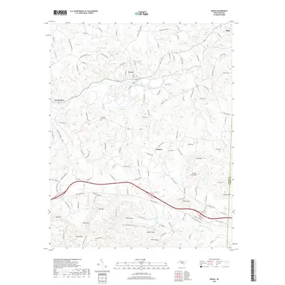
2019 Map of Ronda
USGS Topo · Published 2019About this map
The Yadkin River defines the heart of this landscape, winding through the valley where the town of Ronda and the community of Roaring River were established. The topography transitions from the river's path into the elevated terrain of the Brushy Mountains, characterized by peaks such as Horde Mtn and Redding Mtn. This area reflects a long-standing rural settlement pattern, with family and community identity tied to local landmarks like Old Brier Creek Cem and the Macedonia Church.
Find a feature on this map
127 named features on this map. Tap any name to fly to it.
Don’t see what you’re looking for? This feature index may not catch every label — zoom into the map to look around manually.
Map Details
Editions of this 2019 Ronda Map
This is the sole edition of this map. No revisions or reprints were ever made.
Other maps of this area

1889 · Wilkesboro
USGS Topo · 1:125,000

1891 · Wilkesboro
USGS Topo · 1:125,000

1891 · Yadkinville
USGS Topo · 1:125,000

1893 · Yadkinville
USGS Topo · 1:125,000

1953 · Winston-Salem
USGS Topo · 1:250,000

1955 · Winston-Salem
USGS Topo · 1:250,000

1962 · Winston-Salem
USGS Topo · 1:250,000
1966 · Gilreath
USGS Topo · 1:24,000

1966 · Roaring River
USGS Topo · 1:24,000
1968 · Traphill
USGS Topo · 1:24,000