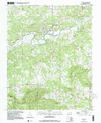
1997 Map of Ronda
USGS Topo · Published 2000About this map
The Yadkin River winds through the heart of this landscape, forming the natural boundary between the river settlements of Ronda and Roaring River. This late-twentieth-century view shows a rural community anchored by its landmarks, including East Wilkes High Sch and Ronda-Clingman Sch. The southern half of the map is defined by the significant elevations of Brush Mountain, where family-named peaks like Mathis Mtn and Byrd Mtn overlook Engle Hollow and Adams Hollow. Local genealogy is well-preserved through numerous rural institutions, from the Brier Creek Cem and Bethel Cem to the Macedonia Ch and Wilkes Temple. The settlement patterns here follow the tight geography of the river valley and the creek systems of Bugaboo Creek and Swan Creek, which cut through the ridges toward the Wilkes and Yadkin county line.
Find a feature on this map
41 named features on this map. Tap any name to fly to it.
Don’t see what you’re looking for? This feature index may not catch every label — zoom into the map to look around manually.
Map Details
Editions of this 1997 Ronda Map
This is the sole edition of this map. No revisions or reprints were ever made.
Other maps of this area

1889 · Wilkesboro
USGS Topo · 1:125,000

1891 · Wilkesboro
USGS Topo · 1:125,000

1891 · Yadkinville
USGS Topo · 1:125,000

1893 · Yadkinville
USGS Topo · 1:125,000

1953 · Winston-Salem
USGS Topo · 1:250,000

1955 · Winston-Salem
USGS Topo · 1:250,000

1962 · Winston-Salem
USGS Topo · 1:250,000
1966 · Gilreath
USGS Topo · 1:24,000

1966 · Roaring River
USGS Topo · 1:24,000
1968 · Traphill
USGS Topo · 1:24,000