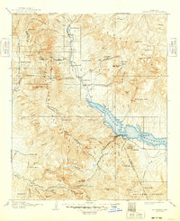
1912 Map of Roosevelt
USGS Topo · Published 1948About this map
Roosevelt Dam stands as the centerpiece of this Arizona landscape, capturing the waters of the Salt River and Tonto Creek to form the sprawling Roosevelt Reservoir. Surveyed between 1905 and 1907, the map illustrates the early development of water management infrastructure in Gila and Maricopa counties, including the emerging Power Line and Electric symbols near the dam site. The surrounding terrain is a network of remote homesteads and waypoints such as Howell's Ranch, Clines Ranch, and Schell's Station. High peaks like Mt Ord and the distinctive Four Peaks define the horizon, while the Tonto National Monument and the Tonto National Forest mark protected lands. Cultural sites like Tortilla Flat and Mormon Flat appear along the river corridors, providing a detailed record of pioneer-era transit and settlement before more modern expansion took hold.
Find a feature on this map
95 named features on this map. Tap any name to fly to it.
Don’t see what you’re looking for? This feature index may not catch every label — zoom into the map to look around manually.
Map Details
Editions of this 1912 Roosevelt Map
4 editions found

Other maps of this area

1886 · Holbrook
USGS Topo · 1:250,000

1887 · Verde
USGS Topo · 1:250,000

1892 · Verde
USGS Topo · 1:250,000

1893 · Holbrook
USGS Topo · 1:250,000

1900 · Florence
USGS Topo · 1:125,000

1901 · Globe
USGS Topo · 1:62,500

1902 · Globe
USGS Topo · 1:62,500

1902 · Florence
USGS Topo · 1:125,000

1904 · Desert Well
USGS Topo · 1:62,500

1904 · Ft. McDowell
USGS Topo · 1:62,500