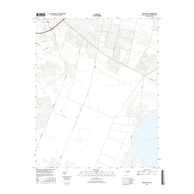
2016 Map of Roper South
USGS Topo · Published 2016About this map
Roper serves as the primary settlement anchor at the northwestern corner of this study, where local streets like Walker St and E Mill Pond Rd radiate into a landscape heavily shaped by hydraulic engineering. The terrain is defined by the expansive East Dismal Swamp, a low-lying region systematically drained by a network of industrial waterways including the Main Canal, Lewis Canal, and Canal A. This grid-like system of canals and access roads, such as A Canal Rd and B Canal Rd, illustrates the intensive land management required to utilize this part of Washington County. To the southeast, the open waters of Phelps Lake provide a sharp contrast to the reclaimed swamp lands. Evidence of former transportation corridors appears in the naming of Railroad Bed Rd, while smaller watercourses like Kendrick Cr continue to meander through the structured drainage blocks near Long Ridge.
Find a feature on this map
22 named features on this map. Tap any name to fly to it.
Don’t see what you’re looking for? This feature index may not catch every label — zoom into the map to look around manually.
Map Details
Editions of this 2016 Roper South Map
This is the sole edition of this map. No revisions or reprints were ever made.
Other maps of this area

1914 · Belhaven
USGS Topo · 1:48,000

1916 · Belhaven
USGS Topo · 1:62,500

1943 · Columbia
USGS Topo · 1:125,000

1943 · Plymouth
USGS Topo · 1:125,000

1953 · Rocky Mount
USGS Topo · 1:250,000

1954 · Rocky Mount
USGS Topo · 1:250,000

1954 · Plymouth East
USGS Topo · 1:24,000

1954 · Roper North
USGS Topo · 1:24,000

1954 · Roper South
USGS Topo · 1:24,000
1954 · Creswell
USGS Topo · 1:24,000