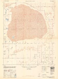
1947 Map of Rosamond Lake
USGS Topo · Published 1947About this map
Rosamond Lake dominates this 1947 survey, appearing as a massive dry lake bed within the expanse of the Mojave Desert. Compiled from 1946 aerial photography by the Army Map Service, the map documents a landscape defined by its grid-like road system and sparse water resources. The southern portion of the sheet shows the early development of the Antelope Valley road network, featuring long, straight corridors such as Avenue C, Avenue D, and Redman Road. Several small reservoirs are scattered across the desert floor, indicating the critical nature of water management in this arid environment. The map captures the area just after World War II, showing a mix of established section lines and emerging rural infrastructure that would eventually support the growth of Los Angeles County's northern reaches.
Find a feature on this map
11 named features on this map. Tap any name to fly to it.
Don’t see what you’re looking for? This feature index may not catch every label — zoom into the map to look around manually.
Map Details
Editions of this 1947 Rosamond Lake Map
2 editions found
Other maps of this area

1915 · Elizabeth Lake
USGS Topo · 1:125,000

1917 · Elizabeth Lake
USGS Topo · 1:125,000

1930 · Oban
USGS Topo · 1:24,000

1930 · Roosevelt School
USGS Topo · 1:24,000

1930 · Casa Desierta
USGS Topo · 1:24,000

1933 · Casa Desierta
USGS Topo · 1:24,000

1933 · Roosevelt School
USGS Topo · 1:24,000

1933 · Oban
USGS Topo · 1:24,000

1937 · Rogers Lake
USGS Topo · 1:48,000

1942 · Rogers Lake
USGS Topo · 1:62,500