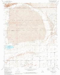
1973 Map of Rosamond Lake
USGS Topo · Published 1983About this map
Edwards Air Force Base dominates this high desert landscape along the border of Kern and Los Angeles Counties. The vast, dry expanse of Rosamond Lake serves as a natural foundation for the Air Force Flight Test Center, illustrating the region's importance to aerospace development in the early 1970s. The southern portion of the map reveals a shift toward managed water resources and desert infrastructure, most notably at the Piute Ponds near the intersection of several surveyed desert roads. A rigid grid of thoroughfares, including 10th Street East and 70th Street East, cut through the terrain toward the Military Reservation Boundary. Small-scale industrial activity is evidenced by scattered sandpits and quarries, while family-named landmarks like Red Hill provide topographic variety in an otherwise flat, alkali-crusted basin.
Find a feature on this map
22 named features on this map. Tap any name to fly to it.
Don’t see what you’re looking for? This feature index may not catch every label — zoom into the map to look around manually.
Map Details
Editions of this 1973 Rosamond Lake Map
2 editions found
Other maps of this area

1915 · Elizabeth Lake
USGS Topo · 1:125,000

1917 · Elizabeth Lake
USGS Topo · 1:125,000

1930 · Oban
USGS Topo · 1:24,000

1930 · Roosevelt School
USGS Topo · 1:24,000

1930 · Casa Desierta
USGS Topo · 1:24,000

1933 · Casa Desierta
USGS Topo · 1:24,000

1933 · Roosevelt School
USGS Topo · 1:24,000

1933 · Oban
USGS Topo · 1:24,000

1937 · Rogers Lake
USGS Topo · 1:48,000

1942 · Rogers Lake
USGS Topo · 1:62,500