1950 Map of Rosario NO
USGS Topo · Published 1950About this map
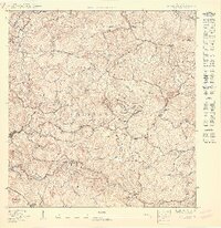
Agricultural life in the central hills of Municipio de Mayagüez is captured in detail by this 1950 survey. The landscape is defined by the steep drainage basins of the Río Yagüez and Río Cañas, where numerous private estates like Hacienda Constanza and Hacienda Recurso mark the traditional land use of the era. These named estates, along with Finca Marini, suggest a region heavily invested in coffee or sugarcane production prior to the rapid industrialization of the mid-20th century.
Find a feature on this map
33 named features on this map. Tap any name to fly to it.
Don’t see what you’re looking for? This feature index may not catch every label — zoom into the map to look around manually.
Map Details
Editions of this 1950 Rosario NO Map
This is the sole edition of this map. No revisions or reprints were ever made.
Other maps of this area

1938 · Alto Sano
USGS Topo · 1:20,000

1939 · Mayaguez
USGS Topo · 1:30,000

1941 · Rincon
USGS Topo · 1:30,000

1941 · Rincon
USGS Topo · 1:30,000

1941 · Rosario
USGS Topo · 1:30,000

1942 · Central La Plata
USGS Topo · 1:30,000

1942 · Rosario
USGS Topo · 1:30,000

1946 · Ciales
USGS Topo · 1:30,000

1947 · Rincon
USGS Topo · 1:30,000

1947 · Rincon
USGS Topo · 1:30,000
Featured Places
- Sector Ramón Román, Mayagüez
- Sector La Ceiba, Mayagüez
- Sector Pascual Perez, Mayagüez
- Sector Luis Ortiz, Mayagüez
- Sector Los Borrero, Mayagüez