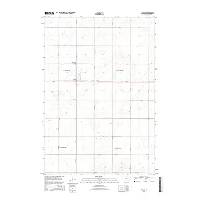
2015 Map of Roscoe
USGS Topo · Published 2015About this map
Roscoe serves as the central hub of this prairie landscape in Edmunds County, situated at the intersection of a grid-like network of rural roads. The town's layout is defined by residential streets like N Richmond St, N Andrew St, and N William St, which branch off the main thoroughfare of 134th St. North of the town center lies the Morningside Cem, a significant site for local genealogical research. This map details the township and range divisions, including t123n r71w, t123n r70w, t122n r71w, and t122n r70w, reflecting the structured land management of the Great Plains. The surrounding terrain is characterized by numerous small, scattered water bodies and wetlands typical of the region's glaciated topography, emphasizing the agricultural and natural character of the area.
Find a feature on this map
25 named features on this map. Tap any name to fly to it.
Don’t see what you’re looking for? This feature index may not catch every label — zoom into the map to look around manually.
Map Details
Editions of this 2015 Roscoe Map
This is the sole edition of this map. No revisions or reprints were ever made.
Other maps of this area

1954 · Aberdeen
USGS Topo · 1:250,000

1956 · Aberdeen
USGS Topo · 1:250,000

1974 · Roscoe
USGS Topo · 1:24,000

1974 · Roscoe SW
USGS Topo · 1:24,000

1978 · Loyalton
USGS Topo · 1:24,000
1978 · Stafford Dam
USGS Topo · 1:24,000

1978 · Beebe
USGS Topo · 1:24,000

1978 · Roscoe NW
USGS Topo · 1:24,000

1978 · Hosmer SE
USGS Topo · 1:24,000

1978 · Hosmer
USGS Topo · 1:24,000