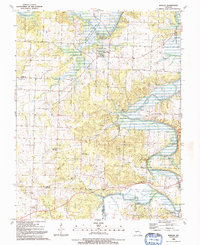
1991 Map of Roscoe
USGS Topo · Published 1991About this map
Roscoe sits at the confluence of the Osage River and the Sac River in this 1991 survey, a landscape defined by sharp bluffs and winding creek valleys along the border of St. Clair and Cedar Counties. The terrain is marked by significant topographical features such as Venter Bluff and Keeton Ridge, with numerous small branches like Bazzill Branch and Cole Branch feeding the larger river systems. A strong sense of local history is preserved through the naming of family landmarks and small community hubs, including the Green Valley Community Center and the Riverview Ch. The map detail includes several burial grounds scattered throughout the rural landscape, from Pleasant Springs Cem in the west to Moore Cem in the north. Large conservation areas like the Roscoe Bottoms State Wildlife Area protect the river bottoms, highlighting the region's balance between agricultural land and natural riverine environments.
Find a feature on this map
52 named features on this map. Tap any name to fly to it.
Don’t see what you’re looking for? This feature index may not catch every label — zoom into the map to look around manually.
Map Details
Editions of this 1991 Roscoe Map
This is the sole edition of this map. No revisions or reprints were ever made.
Other maps of this area

1886 · Stockton
USGS Topo · 1:125,000

1887 · Clinton
USGS Topo · 1:125,000

1894 · Clinton
USGS Topo · 1:125,000

1937 · Tiffin
USGS Topo · 1:31,680

1938 · Monegaw Springs
USGS Topo · 1:24,000

1938 · Roscoe
USGS Topo · 1:24,000

1938 · Vista
USGS Topo · 1:24,000

1938 · Taberville
USGS Topo · 1:24,000

1939 · Caplinger Mills
USGS Topo · 1:24,000

1939 · Osceola
USGS Topo · 1:24,000