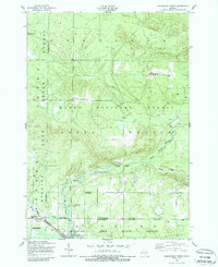
1950 Map of Roscommon North
USGS Topo · Published 1988About this map
South Branch Au Sable River meanders through the heart of the Huron National Forest, anchoring a landscape defined by recreational camps and early 20th-century industry. The 1949 aerial survey and 1950 field check document a specific era of Upper Michigan's wilderness management, where private sporting retreats like the Bay City Hunting and Fishing Club and South Branch Ranch stood alongside active resource extraction. Evidence of the region's logging and homesteading past is scattered across the terrain, notably at Pioneer Cemetery and several sites marked simply as Ruins. The New York Central railroad corridor in the southwest corner near Gerrish provides a sharp contrast to the remote Deerheart Valley, showing how transportation networks supported both the Northern Block and Supply Company and the burgeoning tourist trade at Bell Top Lodge.
Find a feature on this map
23 named features on this map. Tap any name to fly to it.
Don’t see what you’re looking for? This feature index may not catch every label — zoom into the map to look around manually.
Map Details
Editions of this 1950 Roscommon North Map
2 editions found
Other maps of this area

1949 · Grayling
USGS Topo · 1:62,500

1950 · Grayling
USGS Topo · 1:24,000

1950 · Roscommon North
USGS Topo · 1:24,000

1951 · Wakeley Lake
USGS Topo · 1:24,000

1951 · Grayling
USGS Topo · 1:24,000

1951 · Roscommon North
USGS Topo · 1:24,000

1951 · Pere Cheney
USGS Topo · 1:24,000

1954 · Traverse City
USGS Topo · 1:250,000

1958 · Traverse City
USGS Topo · 1:250,000

1963 · Roscommon South
USGS Topo · 1:24,000