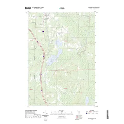
2023 Map of Roscommon South
USGS Topo · Published 2023About this map
Roscommon serves as a focal point for this region, situated near the headwaters of the South Branch Au Sable River. The map illustrates a landscape defined by significant glacial features and wetlands, including Sinkhole Hill and Murray Hill, which rise above the extensive marshes of Robinson Creek Flooding and Long Crossway Swamp. Local administration and community services are anchored by the Roscommon County Courthouse and Higgins Township Cem, while transportation infrastructure is marked by the Roscommon Conservation Airport and an established network of regional roads like Old 76 and Co RD 106. The terrain is characterized by a high water table, evident in the numerous swamps and named drainages like Hudson Creek and Russell Creek that crisscross the sandy plains and low ridges of northern Michigan.
Find a feature on this map
66 named features on this map. Tap any name to fly to it.
Don’t see what you’re looking for? This feature index may not catch every label — zoom into the map to look around manually.
Map Details
Editions of this 2023 Roscommon South Map
This is the sole edition of this map. No revisions or reprints were ever made.
Other maps of this area

1949 · Grayling
USGS Topo · 1:62,500

1950 · Roscommon North
USGS Topo · 1:24,000

1951 · Roscommon North
USGS Topo · 1:24,000

1951 · Pere Cheney
USGS Topo · 1:24,000

1954 · Traverse City
USGS Topo · 1:250,000

1958 · Traverse City
USGS Topo · 1:250,000

1963 · Roscommon South
USGS Topo · 1:24,000

1963 · Backus Lake
USGS Topo · 1:24,000

1963 · Eldorado
USGS Topo · 1:24,000

1963 · Prudenville
USGS Topo · 1:24,000