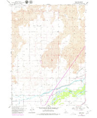
1955 Map of Rose
USGS Topo · Published 1979About this map
Lava formations dominate the northern landscape of this Bingham County survey, terminating abruptly against a dense network of water management systems that transformed the arid terrain. The Snake River flows through the southern portion of the quadrangle, flanked by an intricate web of irrigation infrastructure including the Great Western Canal, Aberdeen-Springfield Canal, and Peoples Canal. This reliance on water engineering is evident in the numerous labeled features such as the Siphon, Flume, and Gaging Sta, which supported the agricultural development of the region. The small settlement of Rose and the nearby Jensen are situated along the Union Pacific Railroad, which parallels the river. Further north, the Boise Base Line serves as a critical surveying boundary across Morgans Pasture, illustrating the early systematic organization of Idaho land.
Find a feature on this map
33 named features on this map. Tap any name to fly to it.
Don’t see what you’re looking for? This feature index may not catch every label — zoom into the map to look around manually.
Map Details
Editions of this 1955 Rose Map
2 editions found
Other maps of this area

1940 · Blackfoot
USGS Topo · 1:62,500

1943 · Blackfoot
USGS Topo · 1:62,500

1948 · Woodville
USGS Topo · 1:24,000

1950 · Woodville
USGS Topo · 1:24,000

1955 · Baldy Knoll
USGS Topo · 1:24,000

1955 · Lincoln Creek
USGS Topo · 1:24,000

1955 · Rose
USGS Topo · 1:24,000

1955 · Firth
USGS Topo · 1:24,000

1955 · Yandell Springs
USGS Topo · 1:62,500

1955 · Idaho Falls
USGS Topo · 1:250,000