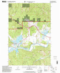
1996 Map of Rose Lake
USGS Topo · Published 1999About this map
Coeur D'Alene River flows through a landscape defined by its wetlands and high timber ridges in the late twentieth century. This survey documents the critical water network of the Coeur d'Alene River State Wildlife Management Area, where the river winds between Rose Lake and Bull Run Lake. The settlement patterns here are modest, centered on the small communities of Rose and Dudley, with a remnant Sawmill and various gravel operations indicating the local resource-based economy. To the north, the terrain climbs sharply into the Coeur d'Alene National Forest through the steep passage of Fourth of July Canyon. The map records a transition from the level floodplain of Mission Flats to the high elevations of Wall Peak and Dudley Peak, capturing the infrastructure of a remote mountain region including an Electronic Site and scattered mountain draws.
Find a feature on this map
36 named features on this map. Tap any name to fly to it.
Don’t see what you’re looking for? This feature index may not catch every label — zoom into the map to look around manually.
Map Details
Editions of this 1996 Rose Lake Map
This is the sole edition of this map. No revisions or reprints were ever made.
Other maps of this area

1903 · Rathdrum
USGS Topo · 1:125,000

1909 · Cataldo
USGS Topo · 1:125,000

1911 · Cataldo
USGS Topo · 1:125,000

1950 · Rochat Peak
USGS Topo · 1:24,000

1950 · Twin Crags
USGS Topo · 1:24,000

1952 · Rochat Peak
USGS Topo · 1:24,000

1952 · Twin Crags
USGS Topo · 1:24,000

1955 · Spokane
USGS Topo · 1:250,000

1957 · St. Maries
USGS Topo · 1:62,500

1957 · Kingston
USGS Topo · 1:62,500