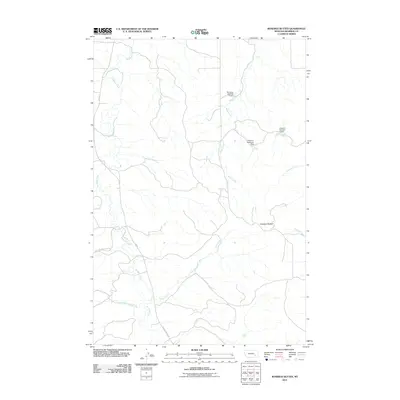
2011 Map of Rosebud Buttes
USGS Topo · Published 2011About this map
Rosebud Buttes anchor this portion of Rosebud County, where the high plains landscape is defined by a dendritic network of drainages. The primary watercourse, Rosebud Creek, is followed by Rosebud Creek Rd and West Rosebud Creek Rd, showing how modern transportation routes continue to adhere to the natural topography of the valley. To the east, the terrain is shaped by Butte Creek and several smaller tributaries like Vance Creek and Runaway Creek. The influence of water management in this arid environment is evident through several named infrastructure points, including Montana Number 9 Dam, Peterson Reservoir Dam, and Langohr Number 1 Dam. These features illustrate the vital role of localized reservoirs for ranching and land use in eastern Montana at the start of the twenty-first century.
Find a feature on this map
13 named features on this map. Tap any name to fly to it.
Don’t see what you’re looking for? This feature index may not catch every label — zoom into the map to look around manually.
Map Details
Editions of this 2011 Rosebud Buttes Map
This is the sole edition of this map. No revisions or reprints were ever made.
Other maps of this area

1954 · Forsyth
USGS Topo · 1:250,000

1957 · Forsyth
USGS Topo · 1:250,000

1958 · Forsyth
USGS Topo · 1:250,000

1968 · Orinoco
USGS Topo · 1:24,000

1968 · Rosebud
USGS Topo · 1:24,000

1968 · Thurlow
USGS Topo · 1:24,000

1971 · Smith Creek NE
USGS Topo · 1:24,000
1971 · Indian Creek
USGS Topo · 1:24,000
1971 · Crain Place
USGS Topo · 1:24,000
1971 · Mc Kerlich Creek
USGS Topo · 1:24,000