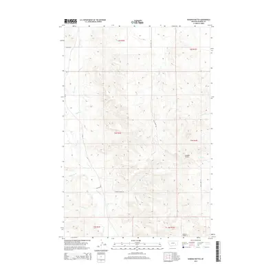
2014 Map of Rosebud Buttes
USGS Topo · Published 2014About this map
Rosebud Buttes rise above a landscape defined by an intricate network of drainage systems in this eastern Montana corridor. The terrain is deeply carved by the main stem of Rosebud Cr and its significant tributary, W Rosebud Cr, which converge in the western half of the quadrangle. This drainage pattern reveals a high-relief coulee system, including Howard Coulee to the south and Runaway Cr to the east, illustrating the complex erosion of the regional plateau. Human activity is marked by rural developments such as Alder Ranch and the Rosebud Estates Dr subdivision, reflecting modern residential and agricultural use of the land. Transportation follows the natural contours of the valley floors, with Butte Creek Rd and Wildcat Rd providing access through the rugged breaks between Vance Cr and Butte Cr.
Find a feature on this map
19 named features on this map. Tap any name to fly to it.
Don’t see what you’re looking for? This feature index may not catch every label — zoom into the map to look around manually.
Map Details
Editions of this 2014 Rosebud Buttes Map
This is the sole edition of this map. No revisions or reprints were ever made.
Other maps of this area

1954 · Forsyth
USGS Topo · 1:250,000

1957 · Forsyth
USGS Topo · 1:250,000

1958 · Forsyth
USGS Topo · 1:250,000

1968 · Orinoco
USGS Topo · 1:24,000

1968 · Rosebud
USGS Topo · 1:24,000

1968 · Thurlow
USGS Topo · 1:24,000

1971 · Smith Creek NE
USGS Topo · 1:24,000
1971 · Indian Creek
USGS Topo · 1:24,000
1971 · Crain Place
USGS Topo · 1:24,000
1971 · Mc Kerlich Creek
USGS Topo · 1:24,000