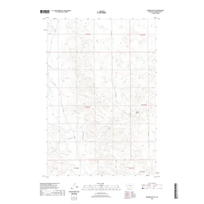
2020 Map of Rosebud Buttes
USGS Topo · Published 2020About this map
Rosebud Buttes stands as a prominent landmark in this section of Rosebud County, where the high plains are carved by an intricate network of drainages. The landscape is defined by the winding paths of Rosebud Cr and its various tributaries, including W Rosebud Cr and Butte Cr. This area reflects a contemporary ranching and rural residential character, with long-established cattle routes like Alder Ranch Rd meeting newer developments such as Rosebud Creek Estates Ln. The map details the complex topography of the region, from the seasonal flows of Runaway Cr and Vance Cr to the southeastern depression of Howard Coulee. These features illustrate the enduring relationship between the drainage basins and the placement of remote access roads like Wildcat Rd and Rte 447.
Find a feature on this map
20 named features on this map. Tap any name to fly to it.
Don’t see what you’re looking for? This feature index may not catch every label — zoom into the map to look around manually.
Map Details
Editions of this 2020 Rosebud Buttes Map
This is the sole edition of this map. No revisions or reprints were ever made.
Other maps of this area

1954 · Forsyth
USGS Topo · 1:250,000

1957 · Forsyth
USGS Topo · 1:250,000

1958 · Forsyth
USGS Topo · 1:250,000

1968 · Orinoco
USGS Topo · 1:24,000

1968 · Rosebud
USGS Topo · 1:24,000

1968 · Thurlow
USGS Topo · 1:24,000

1971 · Smith Creek NE
USGS Topo · 1:24,000
1971 · Indian Creek
USGS Topo · 1:24,000
1971 · Crain Place
USGS Topo · 1:24,000
1971 · Mc Kerlich Creek
USGS Topo · 1:24,000