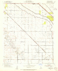
1954 Map of Rosedale
USGS Topo · Published 1955About this map
The Rosedale Oil Field and surrounding petroleum operations dominate this Kern County landscape in the mid-1950s. The map illustrates a highly engineered environment where the Atchison Topeka and Santa Fe railroad cuts a diagonal line across a grid of canals and oil infrastructure. While the Friant-Kern Canal and Lerdo Canal suggest the region's agricultural backbone, the concentration of derricks and a Refinery at Greeley highlight the area's mid-century energy boom. Small communities like Rosedale and Lerdo are anchored by local institutions such as Rosedale Church and Greeley Sch, serving the families tied to both the land and the oil industry. Significant landmarks like Shafter Cemetery and the Rosedale Sta provide vital points of reference for genealogists tracking the growth of these Central Valley settlements before the expansion of nearby urban centers.
Find a feature on this map
35 named features on this map. Tap any name to fly to it.
Don’t see what you’re looking for? This feature index may not catch every label — zoom into the map to look around manually.
Map Details
Editions of this 1954 Rosedale Map
3 editions found
Other maps of this area

1906 · Bakersfield
USGS Topo · 1:62,500

1910 · Buena Vista Lake
USGS Topo · 1:125,000

1912 · Buena Vista Lake
USGS Topo · 1:125,000

1929 · Stevens
USGS Topo · 1:31,680

1929 · Coles Levee
USGS Topo · 1:31,680

1930 · Wasco
USGS Topo · 1:31,680

1930 · Famoso
USGS Topo · 1:31,680

1930 · Rosedale
USGS Topo · 1:31,680

1930 · Oildale
USGS Topo · 1:31,680

1931 · Rio Bravo
USGS Topo · 1:31,680