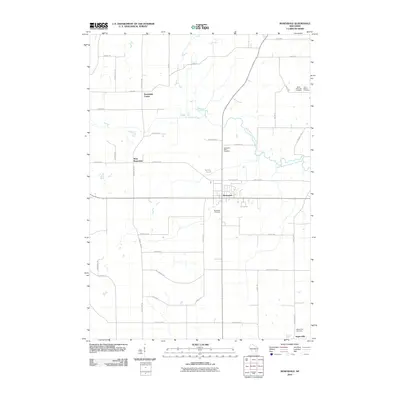
2010 Map of Rosendale
USGS Topo · Published 2010About this map
The village of Rosendale serves as the central hub of this Fond du Lac County agricultural landscape, where the West Branch Fond Du Lac River meanders through the eastern fields. The map reveals a highly structured grid of country lanes and county highways that link smaller hamlets like West Rosendale, Rosendale Center, and Rogersville. This 2010 survey reflects a deeply rooted rural community, marked by numerous burial grounds including Rosendale Cemetery, Rosendale North Cemetery, and Rogersville Cemetery. Genealogists may find value in the naming of local thoroughfares such as Bell School Rd, Zimmerman Rd, and Porter Rd, which often reflect the names of the families who established the surrounding farmsteads. The intersection of County Hwy-M and County Hwy-T provides a clear view of the transport network connecting these Wisconsin townships.
Find a feature on this map
38 named features on this map. Tap any name to fly to it.
Don’t see what you’re looking for? This feature index may not catch every label — zoom into the map to look around manually.
Map Details
Editions of this 2010 Rosendale Map
This is the sole edition of this map. No revisions or reprints were ever made.
Other maps of this area

1916 · Ripon
USGS Topo · 1:48,000

1918 · Ripon
USGS Topo · 1:62,500

1955 · Waupun
USGS Topo · 1:62,500

1955 · Fox Lake
USGS Topo · 1:62,500

1956 · Ripon
USGS Topo · 1:62,500

1956 · Rosendale
USGS Topo · 1:62,500

1957 · Madison
USGS Topo · 1:250,000

1960 · Madison
USGS Topo · 1:250,000

1975 · Waupun NW
USGS Topo · 1:24,000
1975 · Waupun NE
USGS Topo · 1:24,000