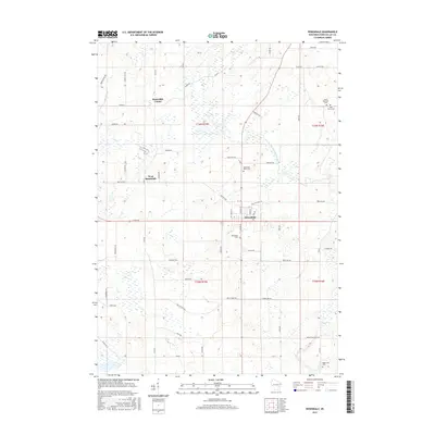
2015 Map of Rosendale
USGS Topo · Published 2015About this map
Agricultural lands and wetland pockets dominate this portion of Fond du Lac County, anchored by the village of Rosendale at the crossing of Co Rd KK and N Main St. The landscape preserves a distinct historical settlement pattern, where smaller clusters like Rosendale Center and West Rosendale mark the expansion of local farming communities. The West Branch Fond Du Lac River meanders through the northeastern section, bordered by seasonal wetlands that have shaped the local road grid. For genealogists and local historians, the map is particularly rich in cemetery data, documenting sites such as Rosendale Cem, Rosendale North Cem, and Saint Marys Cem. This 2015 survey reflects a region where the traditional township and range system, including t16n r15e, remains the primary framework for rural life and property boundaries.
Find a feature on this map
56 named features on this map. Tap any name to fly to it.
Don’t see what you’re looking for? This feature index may not catch every label — zoom into the map to look around manually.
Map Details
Editions of this 2015 Rosendale Map
This is the sole edition of this map. No revisions or reprints were ever made.
Other maps of this area

1916 · Ripon
USGS Topo · 1:48,000

1918 · Ripon
USGS Topo · 1:62,500

1955 · Waupun
USGS Topo · 1:62,500

1955 · Fox Lake
USGS Topo · 1:62,500

1956 · Ripon
USGS Topo · 1:62,500

1956 · Rosendale
USGS Topo · 1:62,500

1957 · Madison
USGS Topo · 1:250,000

1960 · Madison
USGS Topo · 1:250,000

1975 · Waupun NW
USGS Topo · 1:24,000
1975 · Waupun NE
USGS Topo · 1:24,000