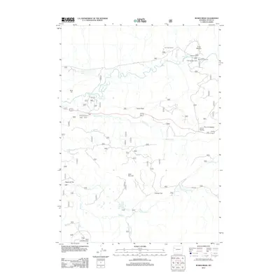
2012 Map of Rosies Ridge
USGS Topo · Published 2012About this map
Buffalo Fork and its tributaries define the hydrological character of this high-country landscape, where the waters of Blackrock Cr and Spread Cr carve through the terrain. The central prominence of Rosies Ridge stands between the river valleys, surrounded by landmark peaks like Baldy Mountain and Burro Hill. This 2012 survey illustrates a region shaped by outdoor recreation and public land management, centered on the Turpin Meadow area. Here, the Turpin Meadow Lodge, Turpin Meadow Campground, and nearby Turpin Meadow Trailhead serve as a hub for backcountry access. Further south, the map identifies significant open spaces such as Sagebrush Flat and the remote Skull Creek Meadows, while smaller water bodies like Tracy Lake and Lily Lake are tucked into the drainages of the Teton wilderness.
Find a feature on this map
26 named features on this map. Tap any name to fly to it.
Don’t see what you’re looking for? This feature index may not catch every label — zoom into the map to look around manually.
Map Details
Editions of this 2012 Rosies Ridge Map
This is the sole edition of this map. No revisions or reprints were ever made.
Other maps of this area

1902 · Mt Leidy
USGS Topo · 1:125,000

1955 · Driggs
USGS Topo · 1:250,000

1958 · Driggs
USGS Topo · 1:250,000

1962 · Driggs
USGS Topo · 1:250,000

1965 · Davis Hill
USGS Topo · 1:24,000

1965 · Green Mountain
USGS Topo · 1:24,000

1965 · Rosies Ridge
USGS Topo · 1:24,000

1965 · Mount Leidy
USGS Topo · 1:24,000

1965 · Tripod Peak
USGS Topo · 1:24,000
1965 · Whetstone Mountain
USGS Topo · 1:24,000