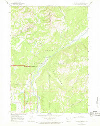
1965 Map of Whetstone Mountain
USGS Topo · Published 1969About this map
Whetstone Mountain dominates this mid-1960s topographic survey of the northern Teton range, illustrating a complex convergence of land management boundaries. The map clearly delineates the Grand Teton National Park border as it meets the Teton National Forest and the Teton Wilderness, providing a precise look at these protected areas before later expansion or reclassification.
Find a feature on this map
19 named features on this map. Tap any name to fly to it.
Don’t see what you’re looking for? This feature index may not catch every label — zoom into the map to look around manually.
Map Details
Editions of this 1965 Whetstone Mountain Map
3 editions found
Other maps of this area

1885 · Lake
USGS Topo · 1:125,000

1886 · Shoshone
USGS Topo · 1:125,000

1888 · Shoshone
USGS Topo · 1:125,000

1895 · Shoshone
USGS Topo · 1:125,000

1895 · Lake
USGS Topo · 1:125,000

1896 · Lake
USGS Topo · 1:125,000

1899 · Grand Teton
USGS Topo · 1:125,000

1901 · Shoshone
USGS Topo · 1:125,000

1901 · Lake
USGS Topo · 1:125,000

1901 · Grand Teton
USGS Topo · 1:125,000