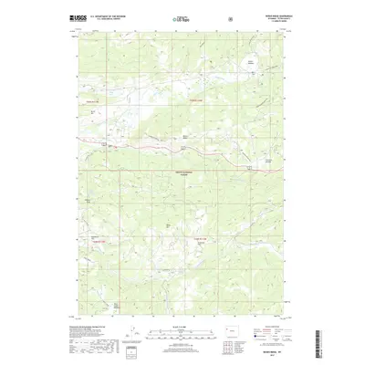
2017 Map of Rosies Ridge
USGS Topo · Published 2017About this map
Teton National Forest encompasses the majority of this landscape, where the high-altitude terrain of the northern Wyoming Rockies is defined by a dense network of watercourses and alpine meadows. The northern portion of the map is dominated by the Buffalo Fork river and its surrounding valleys, including the prominent Turpin Meadow and Tracy Lake. Centrally, Rosies Ridge stands as a significant topographical divide between the Buffalo Fork drainage and the southern waters of Blackrock Cr. This area is characterized by various named open spaces such as Preacher Park and Sagebrush Flat, which punctuate the timbered slopes. Further south, the map details the headwaters and branches of Spread Creek and the marshy basins of Skull Creek Meadows, providing a clear record of the complex hydrography within this protected wilderness area.
Find a feature on this map
32 named features on this map. Tap any name to fly to it.
Don’t see what you’re looking for? This feature index may not catch every label — zoom into the map to look around manually.
Map Details
Editions of this 2017 Rosies Ridge Map
This is the sole edition of this map. No revisions or reprints were ever made.
Other maps of this area

1902 · Mt Leidy
USGS Topo · 1:125,000

1955 · Driggs
USGS Topo · 1:250,000

1958 · Driggs
USGS Topo · 1:250,000

1962 · Driggs
USGS Topo · 1:250,000

1965 · Davis Hill
USGS Topo · 1:24,000

1965 · Green Mountain
USGS Topo · 1:24,000

1965 · Rosies Ridge
USGS Topo · 1:24,000

1965 · Mount Leidy
USGS Topo · 1:24,000

1965 · Tripod Peak
USGS Topo · 1:24,000
1965 · Whetstone Mountain
USGS Topo · 1:24,000