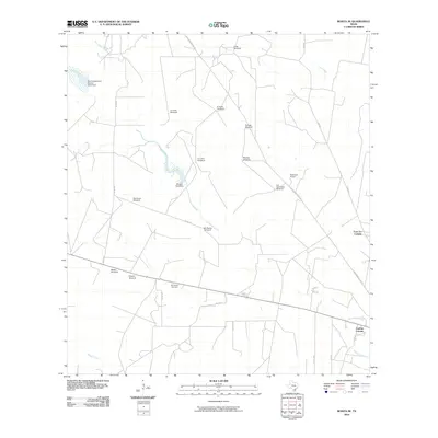
2010 Map of Rosita SE
USGS Topo · Published 2010About this map
San Diego Creek and Rosita Creek drain this South Texas landscape, where the ranching economy is etched into the terrain through an extensive network of water infrastructure. Numerous named landmarks like Sombrero Windmill, La Linea Windmill, and Los Colorados Windmill underscore the necessity of groundwater in this semi-arid region. The presence of the Sepulveda Cemetery and settlements such as Robinson Ranch indicate established family landholdings and small rural communities. These are further complemented by residential developments like Cadena Colonia and Four A's Colonia in the southeast. Infrastructure improvements are visible in the Muralla Tank Dam and Soil Conservation Service Site 5 Dam, while the historic Old Seven Sisters Rd provides a primary corridor through the area.
Find a feature on this map
29 named features on this map. Tap any name to fly to it.
Don’t see what you’re looking for? This feature index may not catch every label — zoom into the map to look around manually.
Map Details
Editions of this 2010 Rosita SE Map
This is the sole edition of this map. No revisions or reprints were ever made.
Other maps of this area

1917 · Ben Bolt
USGS Topo · 1:62,500

1920 · San Diego
USGS Topo · 1:62,500

1956 · Benavides
USGS Topo · 1:62,500

1956 · Rosita Ranch
USGS Topo · 1:62,500

1956 · Laredo
USGS Topo · 1:250,000

1963 · San Diego
USGS Topo · 1:24,000
1963 · Shaeffer Ranch
USGS Topo · 1:24,000

1963 · Ben Bolt NW
USGS Topo · 1:24,000

1968 · Benavides NW
USGS Topo · 1:24,000
1968 · Benavides NE
USGS Topo · 1:24,000