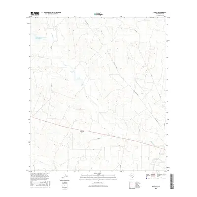
2016 Map of Rosita SE
USGS Topo · Published 2016About this map
San Diego Cr and its tributaries carve a winding path through this Duval County landscape, where ranching and conservation infrastructure define the terrain. The central importance of water management in this arid region is visible through features like the Soil Conservation Service Site 5 Reservoir and the Muralla Tank. For genealogists and local historians, the Sepulveda Cem stands as a significant cultural landmark along the southern roadway. The map's network of rural routes, including the evocatively named Old Seven Sisters Rd and several county roads like Co RD 339, reveals the connectivity between isolated ranch lands and the drainage basins of Rosita Cr and Toro Cr.
Find a feature on this map
21 named features on this map. Tap any name to fly to it.
Don’t see what you’re looking for? This feature index may not catch every label — zoom into the map to look around manually.
Map Details
Editions of this 2016 Rosita SE Map
This is the sole edition of this map. No revisions or reprints were ever made.
Other maps of this area

1917 · Ben Bolt
USGS Topo · 1:62,500

1920 · San Diego
USGS Topo · 1:62,500

1956 · Benavides
USGS Topo · 1:62,500

1956 · Rosita Ranch
USGS Topo · 1:62,500

1956 · Laredo
USGS Topo · 1:250,000

1963 · San Diego
USGS Topo · 1:24,000
1963 · Shaeffer Ranch
USGS Topo · 1:24,000

1963 · Ben Bolt NW
USGS Topo · 1:24,000

1968 · Benavides NW
USGS Topo · 1:24,000
1968 · Benavides NE
USGS Topo · 1:24,000