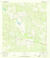
1969 Map of Rosita SE
USGS Topo · Published 1972About this map
Oil Field operations and cattle ranching define this South Texas landscape in the late 1960s. The terrain is characterized by a dense network of windmills that served the local ranching economy, including family-named landmarks like Sombrero Windmill, Alto Bonito Windmill, and Esiquio Windmill. The presence of the Texas Mexican railroad line in the southern portion of the quadrangle, alongside the Old Seven Sisters Road, highlights the importance of transportation for moving goods through this semi-arid region.
Find a feature on this map
28 named features on this map. Tap any name to fly to it.
Don’t see what you’re looking for? This feature index may not catch every label — zoom into the map to look around manually.
Map Details
Editions of this 1969 Rosita SE Map
This is the sole edition of this map. No revisions or reprints were ever made.
Other maps of this area

1917 · Ben Bolt
USGS Topo · 1:62,500

1920 · San Diego
USGS Topo · 1:62,500

1956 · Benavides
USGS Topo · 1:62,500

1956 · Rosita Ranch
USGS Topo · 1:62,500

1956 · Laredo
USGS Topo · 1:250,000

1963 · San Diego
USGS Topo · 1:24,000
1963 · Shaeffer Ranch
USGS Topo · 1:24,000

1963 · Ben Bolt NW
USGS Topo · 1:24,000

1968 · Benavides NW
USGS Topo · 1:24,000
1968 · Benavides NE
USGS Topo · 1:24,000