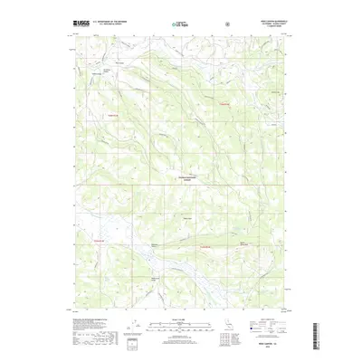
2018 Map of Ross Canyon
USGS Topo · Published 2018About this map
Plumas National Forest dominates this high-altitude landscape, where the Sierra Nevada terrain is defined by a complex network of deep canyons and prominent peaks. The drainage patterns of Last Chance Cr and Squaw Queen Cr carve through the mountain range, creating landforms like Ross Canyon and McReynolds Valley. The map reveals a high-country environment reliant on isolated water sources such as Jenkins Springs and Cow Camp Spring, which were essential for seasonal livestock grazing in these elevations. The presence of routes like the Milford-Beckworth and Janesville-Frenchman roads illustrates the historic transit corridors connecting the Honey Lake Valley to the interior forest and ranching grounds. Significant summits including Squaw Peak and Squaw Valley Peak provide the primary landmarks for navigation in this heavily forested and deeply dissected terrain.
Find a feature on this map
34 named features on this map. Tap any name to fly to it.
Don’t see what you’re looking for? This feature index may not catch every label — zoom into the map to look around manually.
Map Details
Editions of this 2018 Ross Canyon Map
This is the sole edition of this map. No revisions or reprints were ever made.
Other maps of this area

1886 · Honey Lake
USGS Topo · 1:250,000

1890 · Sierraville
USGS Topo · 1:125,000

1891 · Downieville
USGS Topo · 1:125,000

1891 · Honey Lake
USGS Topo · 1:250,000

1892 · Sierraville
USGS Topo · 1:125,000

1893 · Honey Lake
USGS Topo · 1:250,000

1893 · Downieville
USGS Topo · 1:125,000

1894 · Sierraville
USGS Topo · 1:125,000

1895 · Downieville
USGS Topo · 1:125,000

1896 · Downieville
USGS Topo · 1:125,000