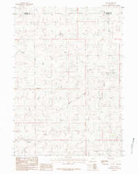
1984 Map of Ross
USGS Topo · Published 1992About this map
Ross marks a singular point of human settlement within this high-plains landscape of the 1980s, situated near the boundary where the Campbell Co Converse Co line divides the terrain. The map reveals an intricate system of ephemeral drainage, where the Fink Prong North Fork South Fork and Wind Creek cut through the topography. These intermittent waterways, along with named features like Smythe Draw and Avery Draw, define the local ranching environment and drainage patterns characteristic of this part of Wyoming. In the southern reach of the sheet, Antelope Creek flows through the open country, while the northern edge is marked by the presence of Red Rock Draw. This survey provides a clear view of the sparse road network and topographical relief that shaped land use in the region during the late twentieth century.
Find a feature on this map
7 named features on this map. Tap any name to fly to it.
Don’t see what you’re looking for? This feature index may not catch every label — zoom into the map to look around manually.
Map Details
Editions of this 1984 Ross Map
2 editions found
Other maps of this area

1954 · Artesian Draw
USGS Topo · 1:24,000

1954 · Pine Tree
USGS Topo · 1:24,000

1954 · Taylor Ranch
USGS Topo · 1:24,000

1955 · Newcastle
USGS Topo · 1:250,000

1955 · Arminto
USGS Topo · 1:250,000

1958 · Arminto
USGS Topo · 1:250,000

1958 · Newcastle
USGS Topo · 1:250,000

1959 · Edgerton
USGS Topo · 1:62,500

1960 · Ross
USGS Topo · 1:62,500

1962 · Arminto
USGS Topo · 1:250,000