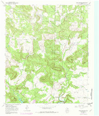
1967 Map of Ross Mountain
USGS Topo · Published 1982About this map
Ross Mountain and its neighboring peaks dominate this landscape at the intersection of Young, Jack, and Palo Pinto counties. The terrain is defined by a series of prominent elevations, including Shin Oak Mountain, Cement Mountain, and Bear Mountain, interspersed with narrow valleys and hollows like Buck Hollow. This area shows a clear pattern of energy and resource extraction, with numerous Oil Wells and a central Gas Plant linked by a complex network of pipelines that traverse the ridges.
Find a feature on this map
35 named features on this map. Tap any name to fly to it.
Don’t see what you’re looking for? This feature index may not catch every label — zoom into the map to look around manually.
Map Details
Editions of this 1967 Ross Mountain Map
This is the sole edition of this map. No revisions or reprints were ever made.
Other maps of this area

1890 · Breckenridge
USGS Topo · 1:125,000

1891 · Palo Pinto
USGS Topo · 1:125,000

1918 · Palo Pinto
USGS Topo · 1:125,000

1924 · Breckenridge 1-a
USGS Topo · 1:48,000

1924 · Palo Pinto 2-b
USGS Topo · 1:48,000

1924 · Palo Pinto 2-a
USGS Topo · 1:48,000

1924 · Graham 4-d
USGS Topo · 1:48,000

1927 · Graham
USGS Topo · 1:62,500

1927 · Pickwick
USGS Topo · 1:62,500

1931 · Ivan
USGS Topo · 1:62,500