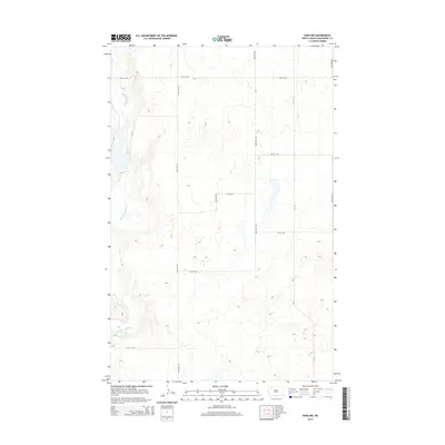
2014 Map of Ross NW
USGS Topo · Published 2014About this map
The White Earth River meanders through the western portion of this Mountrail County landscape, cutting a distinct valley through the high prairie. In this part of North Dakota, the terrain is defined by a rigorous section-line road grid, including 74th St NW and 94th Ave NW, which facilitates the region's agricultural and energy operations. The survey illustrates the rural infrastructure of the early 21st century, where county routes like CR-3111 connect isolated homesteads and industrial sites. Small seasonal basins and wetlands are scattered across the interior, particularly near 92nd Ave NW, providing a detailed look at the local drainage patterns and topography before they meet the river valley.
Find a feature on this map
12 named features on this map. Tap any name to fly to it.
Don’t see what you’re looking for? This feature index may not catch every label — zoom into the map to look around manually.
Map Details
Editions of this 2014 Ross NW Map
This is the sole edition of this map. No revisions or reprints were ever made.
Other maps of this area

1953 · Williston
USGS Topo · 1:250,000

1957 · Williston
USGS Topo · 1:250,000

1969 · Ross NW
USGS Topo · 1:24,000

1969 · White Earth
USGS Topo · 1:24,000

1977 · Powers Lake
USGS Topo · 1:24,000

1978 · Battleview
USGS Topo · 1:24,000
1978 · Lunds Valley
USGS Topo · 1:24,000

1979 · Tioga SE
USGS Topo · 1:24,000

1981 · Ross
USGS Topo · 1:24,000

1981 · Manitou
USGS Topo · 1:24,000