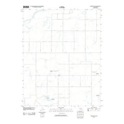
2010 Map of Rosston NE
USGS Topo · Published 2010About this map
Pleasant Valley Cemetery sits at the heart of this rural landscape in Harper County, marking a localized center of gravity for a region defined by its waterway networks. The northern boundary is shaped by the wide path of the Cimarron River, while several tributaries including Redoubt Creek, Stink Creek, and Clark Creek carve through the open country. A rigid grid of section line roads, such as n1800 RD and e0050 RD, organizes the land around a series of numbered reservoirs. These man-made features, including Oknoname 05903 Reservoir and Oknoname 35935 Reservoir, indicate a focus on water management and conservation in this part of Oklahoma. The presence of multiple named dams, such as the Oknoname 05902 Dam, underscores the engineering efforts required to sustain agriculture and local ecosystems in this prairie environment during the early 21st century.
Find a feature on this map
30 named features on this map. Tap any name to fly to it.
Don’t see what you’re looking for? This feature index may not catch every label — zoom into the map to look around manually.
Map Details
Editions of this 2010 Rosston NE Map
This is the sole edition of this map. No revisions or reprints were ever made.
Other maps of this area

1894 · Sitka
USGS Topo · 1:62,500

1896 · Ashland
USGS Topo · 1:125,000

1955 · Woodward
USGS Topo · 1:250,000

1955 · Pratt
USGS Topo · 1:250,000

1958 · Woodward
USGS Topo · 1:250,000

1959 · Pratt
USGS Topo · 1:250,000

1970 · Buffalo NW
USGS Topo · 1:24,000
1970 · Rosston NW
USGS Topo · 1:24,000

1970 · Rosston NE
USGS Topo · 1:24,000

1970 · Buffalo
USGS Topo · 1:24,000