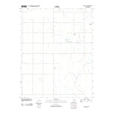
2010 Map of Rosston SE
USGS Topo · Published 2010About this map
Doby Springs Cemetery and Rose Hill Cemetery anchor this section of Harper County, serving as critical landmarks for genealogists and local historians tracking family roots in the Oklahoma Panhandle region. The landscape is defined by the winding course of Buffalo Creek, which meanders through a grid of section roads like n1800 RD and e0130 RD. Water management in this semi-arid environment is evidenced by the Oknoname 05934 Reservoir and its associated Oknoname 05934 Dam, alongside the northern Oknoname 05939 Dam. These engineered features, coupled with the straight-line transit of US Route 64, reflect a landscape organized for agricultural utility and rural connectivity in the early 21st century.
Find a feature on this map
24 named features on this map. Tap any name to fly to it.
Don’t see what you’re looking for? This feature index may not catch every label — zoom into the map to look around manually.
Map Details
Editions of this 2010 Rosston SE Map
This is the sole edition of this map. No revisions or reprints were ever made.
Other maps of this area

1955 · Woodward
USGS Topo · 1:250,000

1958 · Woodward
USGS Topo · 1:250,000

1970 · Buffalo NW
USGS Topo · 1:24,000
1970 · Rosston NW
USGS Topo · 1:24,000

1970 · Rosston NE
USGS Topo · 1:24,000

1970 · Buffalo
USGS Topo · 1:24,000

1971 · Rosston SE
USGS Topo · 1:24,000

1971 · Rosston
USGS Topo · 1:24,000

1971 · Fort Supply NW
USGS Topo · 1:24,000
1971 · Laverne
USGS Topo · 1:24,000