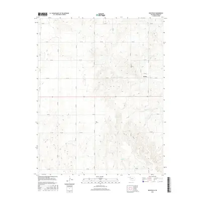
2016 Map of Rosston SE
USGS Topo · Published 2016About this map
Buffalo and the surrounding high plains of Harper County define this region of Northwest Oklahoma as it appeared in the mid-2010s. The landscape is marked by the branching tributaries of Buffalo Cr, which carves through the undulating terrain south of the town center. For genealogists and local historians, the sheet identifies two significant burial sites: Doby Springs Cem in the north and Rose Hill Cem further south. The area is gridded by a systematic network of section line roads, such as N1830 Rd and E0130 Rd, which facilitate transport across this ranching and agricultural landscape. The map provides a clear view of the rural infrastructure and land management patterns typical of the Oklahoma Panhandle borderlands.
Find a feature on this map
25 named features on this map. Tap any name to fly to it.
Don’t see what you’re looking for? This feature index may not catch every label — zoom into the map to look around manually.
Map Details
Editions of this 2016 Rosston SE Map
This is the sole edition of this map. No revisions or reprints were ever made.
Other maps of this area

1955 · Woodward
USGS Topo · 1:250,000

1958 · Woodward
USGS Topo · 1:250,000

1970 · Buffalo NW
USGS Topo · 1:24,000
1970 · Rosston NW
USGS Topo · 1:24,000

1970 · Rosston NE
USGS Topo · 1:24,000

1970 · Buffalo
USGS Topo · 1:24,000

1971 · Rosston SE
USGS Topo · 1:24,000

1971 · Rosston
USGS Topo · 1:24,000

1971 · Fort Supply NW
USGS Topo · 1:24,000
1971 · Laverne
USGS Topo · 1:24,000