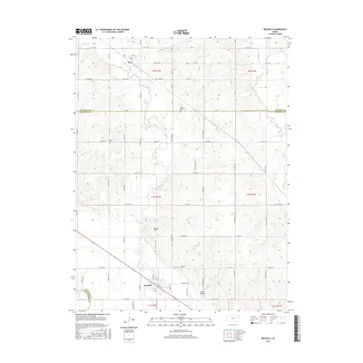
2016 Map of Rossville
USGS Topo · Published 2016About this map
Rossville and the northern settlement of Delia anchor this landscape where the borders of Shawnee, Jackson, and Wabaunsee counties converge. The topography is defined by the winding course of Cross Cr and several smaller tributaries such as Snake Cr and Peanaz Cr, which drain into the Missouri River basin. Cultural history is preserved in several local burial grounds, including the Czech - Moravian Cem and Franklin Cem, reflecting the diverse immigrant heritage of the Kansas prairie. South of the township, the land rises toward Peanaz Hill before descending into Toad Hollow, a pocket of terrain north of the Kansas River valley. The rectilinear road network, featuring routes like NW 54th ST and 94th RD, maintains the strict section-line orientation characteristic of the Great Plains' agricultural development.
Find a feature on this map
42 named features on this map. Tap any name to fly to it.
Don’t see what you’re looking for? This feature index may not catch every label — zoom into the map to look around manually.
Map Details
Editions of this 2016 Rossville Map
This is the sole edition of this map. No revisions or reprints were ever made.
Other maps of this area

1889 · Wamego
USGS Topo · 1:125,000

1889 · Topeka
USGS Topo · 1:125,000

1894 · Topeka
USGS Topo · 1:125,000

1894 · Wamego
USGS Topo · 1:125,000

1950 · Kansas City
USGS Topo · 1:250,000

1952 · Rossville
USGS Topo · 1:24,000

1952 · Silver Lake
USGS Topo · 1:24,000

1952 · Grove
USGS Topo · 1:24,000
1952 · Willard
USGS Topo · 1:24,000

1953 · Maple Hill
USGS Topo · 1:24,000