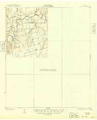
1931 Map of Rotan
USGS Topo · Published 1949About this map
Double Mountain Fork Brazos River carves a winding path across this West Texas landscape, defining the transition between Stonewall and Fisher counties. Surveyed in the late 1920s, the map reveals a rural expanse organized around small community hubs rather than large towns. Local life during this era centered on institutions like Dowell Ch and the neighboring Dowell Sch, which served families across the undulating terrain. To the north, Dorras Sch stands near the headwaters of Canyon Creek, highlighting the importance of school districts in this dispersed ranching and farming country. Regional travel was anchored by the Canadian Del Rio Highway, which follows the river's course, while the sharp meander at Bullock Bend serves as a prominent landmark for the northeastern corner of the quadrangle.
Find a feature on this map
12 named features on this map. Tap any name to fly to it.
Don’t see what you’re looking for? This feature index may not catch every label — zoom into the map to look around manually.
Map Details
Editions of this 1931 Rotan Map
2 editions found
Other maps of this area

1893 · Roby
USGS Topo · 1:125,000

1926 · Snyder 1-a
USGS Topo · 1:48,000

1926 · Roby 2-b
USGS Topo · 1:48,000

1931 · Rotan
USGS Topo · 1:62,500

1931 · Aspermont
USGS Topo · 1:62,500

1932 · Camp Springs
USGS Topo · 1:62,500

1954 · Lubbock
USGS Topo · 1:250,000

1954 · Big Spring
USGS Topo · 1:250,000

1957 · Noodle
USGS Topo · 1:62,500

1958 · Big Spring
USGS Topo · 1:250,000