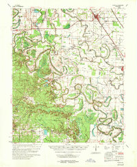
1968 Map of Rotan
USGS Topo · Published 1968About this map
Bartholomew Bayou snakes across this Lincoln County landscape, defining the agricultural and social layout of the region. The density of country churches and family-named schools reflects a deeply established rural community in the late 1960s. Landmarks like Thomas Chapel, Smyrna Ch, and the Wells Bayou School serve as anchors for the surrounding farmsteads. The infrastructure of water management is prominent throughout the terrain, featuring the Pinchback Reservoir, Holthoff Reservoir, and a series of flumes and brakes that supported the local economy.
Find a feature on this map
88 named features on this map. Tap any name to fly to it.
Don’t see what you’re looking for? This feature index may not catch every label — zoom into the map to look around manually.
Map Details
Editions of this 1968 Rotan Map
This is the sole edition of this map. No revisions or reprints were ever made.
Other maps of this area

1935 · Feenyville
USGS Topo · 1:62,500

1935 · Cominto
USGS Topo · 1:62,500

1935 · Varner
USGS Topo · 1:62,500

1935 · Noble Lake
USGS Topo · 1:62,500

1935 · Rotan
USGS Topo · 1:62,500

1935 · Red Fork
USGS Topo · 1:62,500

1935 · Gillett
USGS Topo · 1:62,500

1936 · McGehee
USGS Topo · 1:62,500

1937 · McGehee
USGS Topo · 1:62,500

1948 · Helena
USGS Topo · 1:250,000