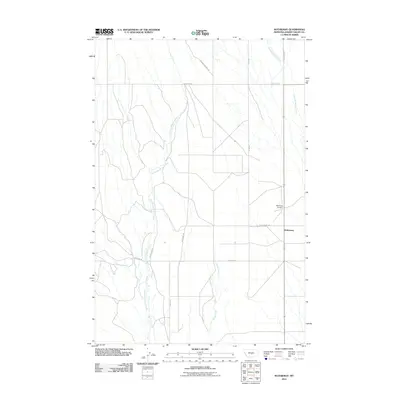
2011 Map of Rothiemay
USGS Topo · Published 2011About this map
Rothiemay and its surrounding ranchlands in Golden Valley County are defined by the winding drainages of Swimming Woman Creek and Merrills Springs Creek. This 2011 survey illustrates a sparse Montana landscape structured by a grid of rural routes, including Swimming Woman Rd and Judith Gap Rd. The settlement of Rothiemay itself is situated near the eastern edge of the quadrangle, with the Rothiemay Cemetery located just to the north. Further south, the intermittent flow of Alkali Creek marks the transition toward more arid terrain. This map serves as an essential record for local history research, showing the precise placement of named family roads like Willems Rd and Pirrie Ln against the backdrop of the Big Sky's hydrography and high plains geography.
Find a feature on this map
13 named features on this map. Tap any name to fly to it.
Don’t see what you’re looking for? This feature index may not catch every label — zoom into the map to look around manually.
Map Details
Editions of this 2011 Rothiemay Map
This is the sole edition of this map. No revisions or reprints were ever made.
Other maps of this area

1889 · Big Snowy Mountain
USGS Topo · 1:250,000

1893 · Big Snowy Mountain
USGS Topo · 1:250,000

1954 · Roundup
USGS Topo · 1:250,000

1958 · Roundup
USGS Topo · 1:250,000

1986 · Patterson Canyon
USGS Topo · 1:24,000
1986 · Snow Saucer Coulee
USGS Topo · 1:24,000

1986 · Halbert Creek South
USGS Topo · 1:24,000

1986 · Halbert Creek North
USGS Topo · 1:24,000

1986 · Wallum
USGS Topo · 1:24,000

1986 · Cushman NW
USGS Topo · 1:24,000