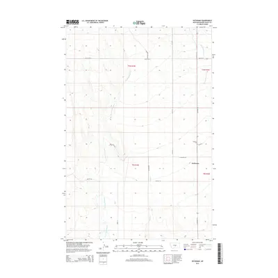
2014 Map of Rothiemay
USGS Topo · Published 2014About this map
The high plains of Golden Valley County define the landscape of Rothiemay, a small community located at the intersection of Rothiemay Rd and W Rothiemay Rd. This area of central Montana is characterized by a network of seasonal and perennial watercourses, most notably the meandering Swimming Woman Cr which drains the western portion of the quadrangle. Other drainage patterns are established by Alkali Cr and Merrills Springs Cr to the east. Local history is anchored at the Rothiemay Cem, situated just north of the town site. The map reflects a rural economy dependent on a grid of county roads, including Judith Gap Rd and Allen Rd, which connect isolated homesteads and ranching properties across the township boundaries of T10N and T9N.
Find a feature on this map
17 named features on this map. Tap any name to fly to it.
Don’t see what you’re looking for? This feature index may not catch every label — zoom into the map to look around manually.
Map Details
Editions of this 2014 Rothiemay Map
This is the sole edition of this map. No revisions or reprints were ever made.
Other maps of this area

1889 · Big Snowy Mountain
USGS Topo · 1:250,000

1893 · Big Snowy Mountain
USGS Topo · 1:250,000

1954 · Roundup
USGS Topo · 1:250,000

1958 · Roundup
USGS Topo · 1:250,000

1986 · Patterson Canyon
USGS Topo · 1:24,000
1986 · Snow Saucer Coulee
USGS Topo · 1:24,000

1986 · Halbert Creek South
USGS Topo · 1:24,000

1986 · Halbert Creek North
USGS Topo · 1:24,000

1986 · Wallum
USGS Topo · 1:24,000

1986 · Cushman NW
USGS Topo · 1:24,000