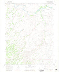
1969 Map of Roubideau
USGS Topo · Published 1981About this map
The Gunnison River carves through the northern portion of this landscape, accompanied by the critical transit corridor of the Denver and Rio Grande Western Railroad. This area, situated along the boundary of Delta and Montrose Counties, illustrates a rugged western environment where water management is central to the land's utility. From the broad expanse of Cactus Park to the high ground of Twentyfive Mesa and Winter Mesa, the terrain is deeply incised by drainages like Roubideau Creek and Cottonwood Creek. Human presence is marked by isolated features such as the Roubideau Conservation Training Camp and various water control structures, including Club Gulch Reservoir and the Ironstone Canal, which demonstrate the ongoing efforts to harness the region's limited water resources for ranching or industry.
Find a feature on this map
31 named features on this map. Tap any name to fly to it.
Don’t see what you’re looking for? This feature index may not catch every label — zoom into the map to look around manually.
Map Details
Editions of this 1969 Roubideau Map
4 editions found
Other maps of this area

1956 · Moab
USGS Topo · 1:250,000

1959 · Moab
USGS Topo · 1:250,000

1960 · Moab
USGS Topo · 1:250,000

1962 · Moab
USGS Topo · 1:250,000
1962 · North Delta
USGS Topo · 1:24,000
1962 · Hoovers Corner
USGS Topo · 1:24,000
1962 · Delta
USGS Topo · 1:24,000

1964 · Moab
USGS Topo · 1:250,000

1965 · Moab
USGS Topo · 1:250,000
1965 · Point Creek
USGS Topo · 1:24,000