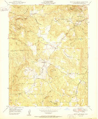
1950 Map of Rough And Ready
USGS Topo · Published 1950About this map
Rough and Ready serves as a historic focal point in this Gold Country landscape, situated among the hydraulic mining legacy of western Nevada County. The terrain is defined by a complex network of water infrastructure, including the Excelsior Ditch and China Hill flumes, which once channeled water to gold operations. While Penn Valley occupies the central flats, the surrounding ridges and peaks like Pilot Peak and Vandervere Mtn rise above a landscape scattered with inactive mineral claims. This era shows the post-war footprint of the Camp Beale Military Reservation occupying the southwestern portion of the map, while civilian life continues at local hubs like Casey Corner and the Clear Creek Sch. The map preserves the specific locations of several legacy mines, such as the Kentucky Ridge Mine and the Niagara Mine, alongside family-named geography like Anthony House and Slacks.
Find a feature on this map
37 named features on this map. Tap any name to fly to it.
Don’t see what you’re looking for? This feature index may not catch every label — zoom into the map to look around manually.
Map Details
Editions of this 1950 Rough And Ready Map
This is the sole edition of this map. No revisions or reprints were ever made.
Other maps of this area

1888 · Smartsville
USGS Topo · 1:125,000

1891 · Smartsville
USGS Topo · 1:125,000

1892 · Smartsville
USGS Topo · 1:125,000

1894 · Smartsville
USGS Topo · 1:125,000

1895 · Smartsville
USGS Topo · 1:125,000

1915 · Spenceville
USGS Topo · 1:31,680

1941 · Bangor
USGS Topo · 1:62,500

1944 · Bangor
USGS Topo · 1:62,500

1948 · Nevada City
USGS Topo · 1:62,500
1948 · Oregon House
USGS Topo · 1:24,000