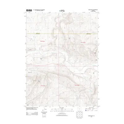
2013 Map of Rough Gulch
USGS Topo · Published 2013About this map
The White River valley carves through this high-desert landscape in Rio Blanco County, following a path roughly parallel to Co-64. The area is defined by massive plateau features like Stadtman Mesa and Blair Mesa, separated by a complex network of drainage systems such as Rough Gulch and McAndrews Gulch. This 2013 survey illustrates the rugged northwestern Colorado topography just south of the Moffat County line, where prominent elevations like Pinyon Ridge and Coal Ridge overlook deep incisions in the earth. Water sources are critical identifiers in this arid environment, evidenced by the presence of Lambert Spring, Stinking Spring, and seasonal flows like Yellow Creek and Greasewood Creek. Historically a region of ranching and resource extraction, the map also shows the infrastructure of CO Road 89 winding through Hay Canyon and Short Canyon.
Find a feature on this map
27 named features on this map. Tap any name to fly to it.
Don’t see what you’re looking for? This feature index may not catch every label — zoom into the map to look around manually.
Map Details
Editions of this 2013 Rough Gulch Map
This is the sole edition of this map. No revisions or reprints were ever made.
Other maps of this area

1907 · Rangely
USGS Topo · 1:125,000

1907 · White River
USGS Topo · 1:125,000

1910 · White River
USGS Topo · 1:125,000

1910 · Rangely
USGS Topo · 1:125,000

1954 · Vernal
USGS Topo · 1:250,000

1958 · Vernal
USGS Topo · 1:250,000

1960 · Vernal
USGS Topo · 1:250,000

1960 · Elk Springs
USGS Topo · 1:62,500
1962 · Calamity Ridge
USGS Topo · 1:24,000
1962 · Divide Creek
USGS Topo · 1:24,000