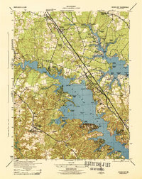
1944 Map of Round Bay
USGS Topo · Published 1944About this map
The Severn River and Magothy River define the intricate shoreline of Anne Arundel County during the mid-1940s, a period when the tidal creeks and peninsulas were home to numerous distinct residential and recreational settlements. The Baltimore and Annapolis RR cuts a straight path through the landscape, connecting communities like Severna Park, Robinson, and Earleigh Heights. These rail-side settlements contrast with the water-oriented clusters at Herald Harbor, Manhattan Beach, and Beachwood Grove, reflecting the region's development as both a transportation corridor and a waterfront retreat.
Find a feature on this map
90 named features on this map. Tap any name to fly to it.
Don’t see what you’re looking for? This feature index may not catch every label — zoom into the map to look around manually.
Map Details
Editions of this 1944 Round Bay Map
This is the sole edition of this map. No revisions or reprints were ever made.
Other maps of this area

1892 · Owensville
USGS Topo · 1:62,500

1892 · Annapolis
USGS Topo · 1:62,500

1893 · North Point
USGS Topo · 1:62,500

1894 · Relay
USGS Topo · 1:62,500

1895 · Owensville
USGS Topo · 1:62,500

1898 · Choptank
USGS Topo · 1:125,000

1898 · Tolchester
USGS Topo · 1:125,000

1899 · Patuxent
USGS Topo · 1:125,000

1903 · Tolchester
USGS Topo · 1:125,000

1904 · North Point
USGS Topo · 1:62,500