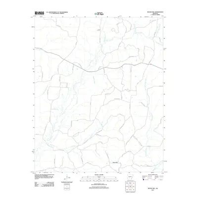
2011 Map of Round Hill
USGS Topo · Published 2011About this map
The settlement of Round Hill anchors the southern portion of this Dallas County landscape, where the geography is defined by an intricate network of waterways. The prominent L'Eau Frais Creek and its tributaries, including Little L'Eau Frais Creek and Greasy Creek, carve a winding path through the region. In the north, Sardis Cemetery offers a point of interest for genealogists tracing local family roots. The road network consists primarily of numbered county routes and named tracks such as Hammond Trl and Tugwell Rd, alongside specialized routes like the Gunnysack Tram and Green Camp Tram, which hint at the area's history of timber or resource transport. From the western reach of Brown Springs Branch to the eastern flow of Little Cypress Creek, the map illustrates a rural Arkansas environment centered on small-scale settlement and natural drainage patterns.
Find a feature on this map
66 named features on this map. Tap any name to fly to it.
Don’t see what you’re looking for? This feature index may not catch every label — zoom into the map to look around manually.
Map Details
Editions of this 2011 Round Hill Map
This is the sole edition of this map. No revisions or reprints were ever made.
Other maps of this area

1948 · Malvern
USGS Topo · 1:62,500

1949 · Malvern
USGS Topo · 1:62,500

1955 · Little Rock
USGS Topo · 1:250,000

1956 · Little Rock
USGS Topo · 1:250,000

1960 · Little Rock
USGS Topo · 1:250,000

1964 · Poyen
USGS Topo · 1:24,000

1964 · Little Rock
USGS Topo · 1:250,000

1964 · Donaldson
USGS Topo · 1:24,000

1965 · Round Hill
USGS Topo · 1:24,000
1965 · Willow
USGS Topo · 1:24,000