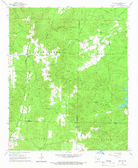
1965 Map of Willow
USGS Topo · Published 1966About this map
The Chicago Rock Island and Pacific railroad forms a clear north-south spine through this mid-1960s landscape, connecting the small communities of Rolla and Willow. The map highlights a rural region where small settlements like Lono and Brush Creek are defined by their proximity to local watercourses like L'Eau Frais Cr and West Fork Tulip Creek. A distinct network of family-named roads, including Phillips Cemetery Road, Brashears Road, and Huskey Road, indicates a deeply rooted local community. Genealogists will find several burial grounds such as Gray Cem, Lono Cem, and Phillips Cem well-documented. The terrain is characterized by gradual elevation changes like Locust Hill and the Flat Pine area, with the eastern border marked by the waters of Cox Creek Lake. Industrial activity is noted through scattered Gravel Pits concentrated near the rail line.
Find a feature on this map
44 named features on this map. Tap any name to fly to it.
Don’t see what you’re looking for? This feature index may not catch every label — zoom into the map to look around manually.
Map Details
Editions of this 1965 Willow Map
3 editions found
Other maps of this area

1948 · Malvern
USGS Topo · 1:62,500

1949 · Malvern
USGS Topo · 1:62,500

1955 · Little Rock
USGS Topo · 1:250,000

1956 · Little Rock
USGS Topo · 1:250,000

1960 · Little Rock
USGS Topo · 1:250,000

1963 · Prattsville
USGS Topo · 1:24,000

1964 · Poyen
USGS Topo · 1:24,000

1964 · Little Rock
USGS Topo · 1:250,000

1965 · Round Hill
USGS Topo · 1:24,000
1965 · Leola
USGS Topo · 1:24,000