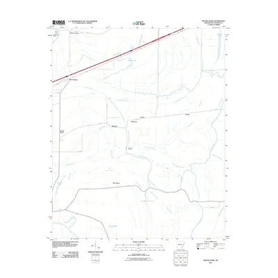
2011 Map of Round Pond
USGS Topo · Published 2011About this map
Saint Francis River and its intricate drainage network define this corner of St. Francis County, where the Arkansas Delta landscape is carved by numerous bayous and sloughs. Small agricultural settlements like Blackfish and Lucerne are connected by a grid of county roads, reflecting a long-standing pattern of rural habitation. The area around Hicks Station and Clarks Corner shows the intersection of modern transport corridors with older landmarks such as Dillon Ferry at Johnson Bend. For local historians and genealogists, the map preserves the location of Whitmore Cemetery and distinct rural communities including New Home and Cicalla. Water bodies such as Beaver Lake, Pettijohn Lake, and Nichols Lake punctuate the lowlands, while the winding paths of North Blackfish Bayou and Tenmile Bayou trace the natural hydrology of the Mississippi Alluvial Plain.
Find a feature on this map
39 named features on this map. Tap any name to fly to it.
Don’t see what you’re looking for? This feature index may not catch every label — zoom into the map to look around manually.
Map Details
Editions of this 2011 Round Pond Map
This is the sole edition of this map. No revisions or reprints were ever made.
Other maps of this area

1931 · Horseshoe Lake
USGS Topo · 1:62,500

1939 · Horseshoe Lake
USGS Topo · 1:62,500

1939 · Park Place
USGS Topo · 1:62,500

1939 · Edmondson
USGS Topo · 1:62,500

1940 · Whitmore
USGS Topo · 1:62,500

1948 · Helena
USGS Topo · 1:250,000

1950 · Helena
USGS Topo · 1:250,000

1953 · Memphis
USGS Topo · 1:250,000

1954 · Horseshoe Lake
USGS Topo · 1:62,500

1954 · Edmondson
USGS Topo · 1:62,500