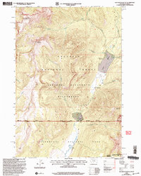
2000 Map of Roundhead Butte
USGS Topo · Published 2005About this map
Frenchy's Grave Historic Site sits as a quiet historical marker within the high backcountry where the Gallatin National Forest meets the Absaroka Beartooth Wilderness. This landscape is defined by the drainage of Slough Creek, which flows south toward Yellowstone National Park, passing the Slough Creek Ranger Station and the isolated Silver Tip Ranch. The terrain rises sharply from Frenchy Meadow to prominent heights like Lookout Mountain and Roundhead Butte. The presence of the Slough Creek Trail indicates the primary corridor for movement through these mountain gaps, connecting the Gardiner Ranger District with the wilderness interior. The map also records the Montana Wyoming Indefinite Boundary, illustrating the complex surveying of this high-altitude borderland where names like Wolverine Creek and Tucker Creek mark the rugged hydrology of the Yellowstone frontier.
Find a feature on this map
26 named features on this map. Tap any name to fly to it.
Don’t see what you’re looking for? This feature index may not catch every label — zoom into the map to look around manually.
Map Details
Editions of this 2000 Roundhead Butte Map
This is the sole edition of this map. No revisions or reprints were ever made.
Other maps of this area

1886 · Canyon
USGS Topo · 1:125,000

1891 · Livingston
USGS Topo · 1:250,000

1893 · Livingston
USGS Topo · 1:250,000

1895 · Canyon
USGS Topo · 1:125,000

1896 · Canyon
USGS Topo · 1:125,000

1901 · Canyon
USGS Topo · 1:125,000

1907 · Canyon
USGS Topo · 1:125,000

1911 · Canyon
USGS Topo · 1:125,000

1940 · Mt Wallace
USGS Topo · 1:62,500

1942 · Cutoff Mtn
USGS Topo · 1:62,500