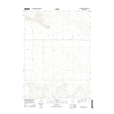
2014 Map of Roundhouse Rock
USGS Topo · Published 2014About this map
Roundhouse Rock dominates the northern landscape of this Morrill County region, serving as a prominent landmark in a territory defined by high plains drainage systems. This 2014 survey illustrates a rural landscape where traditional ranching operations like Horsehead Ranch persist alongside the historical geography of the area. Waterways including Pumpkin Cr, Lawrence Fork, and Middle Creek carve through the terrain, dictating the placement of the section-line road network that includes Ne-88 and several numbered county routes. The settlement at Mud Springs in the southeast corner marks a point of historical interest in an area otherwise characterized by its open range and significant topographic relief. The map reveals the enduring pattern of large-scale landholdings and the sparse, purposeful infrastructure required to navigate this portion of the Nebraska Panhandle.
Find a feature on this map
16 named features on this map. Tap any name to fly to it.
Don’t see what you’re looking for? This feature index may not catch every label — zoom into the map to look around manually.
Map Details
Editions of this 2014 Roundhouse Rock Map
This is the sole edition of this map. No revisions or reprints were ever made.
Other maps of this area

1898 · Camp Clarke
USGS Topo · 1:125,000

1954 · Scottsbluff
USGS Topo · 1:250,000

1958 · Scottsbluff
USGS Topo · 1:250,000

1965 · Bridgeport NW
USGS Topo · 1:24,000

1965 · South Bayard
USGS Topo · 1:24,000

1965 · Courthouse Rock
USGS Topo · 1:24,000
1965 · Bridgeport
USGS Topo · 1:24,000

1972 · Horsehead Ranch
USGS Topo · 1:24,000
1972 · Mud Springs
USGS Topo · 1:24,000

1973 · Bridgeport SW
USGS Topo · 1:24,000