
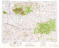
1954 Map of Roundup
USGS Topo · Published 1966About this map
The Musselshell River carves a path through this mid-century landscape of Central Montana, defining a region where the high plains meet significant mountain ranges. In the northern section, the Big Snowy Mountains rise to Greathouse Peak, while the Little Snowy Mountains extend further east. The economic life of the mid-1960s is evidenced by the intersection of rail and road, with the Chicago Milwaukee St Paul and Pacific railroad serving vital agricultural hubs like Harlowton and Roundup.
Find a feature on this map
51 named features on this map. Tap any name to fly to it.
Don’t see what you’re looking for? This feature index may not catch every label — zoom into the map to look around manually.
Map Details
Editions of this 1954 Roundup Map
2 editions found
Other maps of this area

1886 · Little Belt Mts.
USGS Topo · 1:250,000

1889 · Big Snowy Mountain
USGS Topo · 1:250,000

1890 · Fort Benton
USGS Topo · 1:250,000

1891 · Livingston
USGS Topo · 1:250,000

1891 · Big Timber
USGS Topo · 1:125,000

1892 · Fort Benton
USGS Topo · 1:250,000

1892 · Stillwater
USGS Topo · 1:125,000

1893 · Livingston
USGS Topo · 1:250,000

1893 · Big Snowy Mountain
USGS Topo · 1:250,000

1893 · Big Timber
USGS Topo · 1:125,000