1954 Map of Roundup
USGS Topo · Published 1973About this map
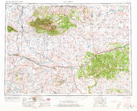
The Musselshell River carves a path through this central Montana landscape, where the high peaks of the Big Snowy Mountains and Little Snowy Mountains dominate the northern horizon. In the mid-1950s, this region remained a vital corridor for western rail transport, anchored by the Chicago Milwaukee St Paul and Pacific and the Great Northern lines. These tracks connected ranching hubs like Harlowton and Roundup to larger markets, while also serving smaller sidings such as Shawmut and Judith Gap.
Find a feature on this map
55 named features on this map. Tap any name to fly to it.
Don’t see what you’re looking for? This feature index may not catch every label — zoom into the map to look around manually.
Map Details
Editions of this 1954 Roundup Map
2 editions found

Other maps of this area

1886 · Little Belt Mts.
USGS Topo · 1:250,000

1889 · Big Snowy Mountain
USGS Topo · 1:250,000

1890 · Fort Benton
USGS Topo · 1:250,000

1891 · Livingston
USGS Topo · 1:250,000

1891 · Big Timber
USGS Topo · 1:125,000

1892 · Fort Benton
USGS Topo · 1:250,000

1892 · Stillwater
USGS Topo · 1:125,000

1893 · Livingston
USGS Topo · 1:250,000

1893 · Big Snowy Mountain
USGS Topo · 1:250,000

1893 · Big Timber
USGS Topo · 1:125,000