1958 Map of Roundup
USGS Topo · Published 1978About this map
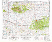
The Big Snowy Mountains dominate the central landscape of this central Montana region, rising sharply above the surrounding plains to reach Greathouse Peak. Within the shelter of these heights lies a portion of the Lewis and Clark National Forest, while the lowland areas are defined by the winding course of the Musselshell River. The map captures a transition in the mid-century economy, showing the presence of energy extraction at the Big Wall Oil Field alongside a dense network of water management features like Deepmans Basin Reservoir and the War Horse N W R (Yellow Water Unit).
Find a feature on this map
84 named features on this map. Tap any name to fly to it.
Don’t see what you’re looking for? This feature index may not catch every label — zoom into the map to look around manually.
Map Details
Editions of this 1958 Roundup Map
2 editions found

Other maps of this area

1886 · Little Belt Mts.
USGS Topo · 1:250,000

1889 · Big Snowy Mountain
USGS Topo · 1:250,000

1890 · Fort Benton
USGS Topo · 1:250,000

1891 · Livingston
USGS Topo · 1:250,000

1891 · Big Timber
USGS Topo · 1:125,000

1892 · Fort Benton
USGS Topo · 1:250,000

1892 · Stillwater
USGS Topo · 1:125,000

1893 · Livingston
USGS Topo · 1:250,000

1893 · Big Snowy Mountain
USGS Topo · 1:250,000

1893 · Big Timber
USGS Topo · 1:125,000