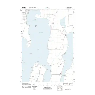
2011 Map of Rouses Point
USGS Topo · Published 2011About this map
Lake Champlain dominates this borderland geography, where the northern waters meet the international boundary at Rouses Point. The landscape is defined by the prominent Alburg Tongue and the island of Isle la Motte, connected by the Rouses Point Bridge and North Hero Bridge. Maritime infrastructure is central to the area's character, featuring the Isle La Motte Lighthouse, Lighthouse Point Mariana, and the Rouses Point Seaplane Base. Local history is preserved in numerous burial grounds across the Vermont and New York shores, including the Bush Cemetery and Reynolds McGregor Cemetery. The map details the transition from the concentrated settlement at Alburg Center to the more dispersed lakeside residences along N Shore Rd and Fiske Rd, while the eastern side shows the managed waters of Mud Creek Pond and the Mud Creek Dam.
Find a feature on this map
74 named features on this map. Tap any name to fly to it.
Don’t see what you’re looking for? This feature index may not catch every label — zoom into the map to look around manually.
Map Details
Editions of this 2011 Rouses Point Map
This is the sole edition of this map. No revisions or reprints were ever made.
Other maps of this area

1895 · Rouse Point
USGS Topo · 1:62,500

1907 · Rouse Point
USGS Topo · 1:62,500

1914 · St. Albans
USGS Topo · 1:48,000

1916 · St. Albans
USGS Topo · 1:62,500

1939 · Rouses Point
USGS Topo · 1:62,500

1943 · Rouses Point
USGS Topo · 1:62,500

1943 · St. Albans
USGS Topo · 1:62,500

1950 · Lake Champlain
USGS Topo · 1:250,000

1956 · Rouses Point
USGS Topo · 1:62,500

1958 · Lake Champlain
USGS Topo · 1:250,000